
Table of Contents
Top Headlines
- India weather today: The India Meteorological Department (IMD) has forecast another active monsoon day on September 18, with heavy rainfall possible in parts of northern, eastern and southern India.
- Heavy rain alert: Bihar, Odisha, parts of West Bengal, Kerala and other regions are expected to experience significant rainfall, with thunderstorms and lightning possible in several areas.
- Strong winds: Gusty winds may accompany thunderstorms in some parts of the country, with speeds potentially reaching around 50–60 kmph in exposed areas.
- Delhi-NCR weather: Delhi, Haryana, Chandigarh and Punjab are among the areas expected to see rainfall activity during the current weather spell.
- Odisha forecast: Odisha is expected to receive isolated to scattered rainfall on September 18, with heavy rainfall possible in some locations.
- Kerala rainfall: Kerala and Mahe are forecast to receive widespread rainfall around September 17–18, with heavy rain possible during this period.
- Bay of Bengal system: IMD says a low-pressure area is likely to form over the Andaman Sea and adjoining areas around September 19.
- Monsoon withdrawal: The southwest monsoon is expected to begin withdrawing from parts of northwest India around September 19, although rainfall will continue in several regions.
India Weather News Today
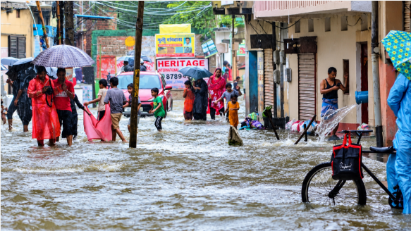
India is experiencing another spell of active monsoon weather on Friday, September 18, 2026, with the latest IMD forecasts indicating rainfall across several parts of the country. Heavy showers, thunderstorms, lightning and gusty winds are expected in different regions, while some areas could receive isolated heavy to very heavy rainfall.
The weather comes as the southwest monsoon approaches its seasonal withdrawal phase in northwest India. IMD has indicated that withdrawal could begin around September 19, but this does not mean the monsoon will immediately end across the entire country. Rainfall activity is expected to continue across eastern, southern and other parts of India.
Heavy Rain Forecast Across Eastern India
Eastern India remains one of the key regions to watch today. Bihar and Odisha are expected to receive rainfall, with heavy showers possible in some locations. Odisha is forecast to see isolated to scattered rainfall on September 18, while rainfall is expected to become more widespread over the following days.
Sub-Himalayan West Bengal is also expected to experience rainfall activity. The IMD forecast indicates fairly widespread rainfall during September 16–18, while thunderstorms and lightning remain possible in some areas.

For residents and travellers in these areas, sudden downpours could affect road conditions and visibility. Local weather warnings should be monitored, particularly during thunderstorms.
Delhi, Punjab and North India Weather
Northern India is also expected to experience unsettled weather. Delhi, Haryana, Chandigarh and Punjab are among the areas where rainfall activity has been forecast. Thunderstorms and gusty winds could accompany showers in some locations.
The IMD forecast indicates that Jammu and Kashmir, Ladakh and neighbouring areas may also see isolated to scattered rainfall on September 18, with thunderstorms and lightning possible during the period.
Weather conditions could therefore remain changeable across the northern plains, with cloudy skies and intermittent showers in several places.
South India Rainfall Update
Southern states are also seeing continued monsoon activity. Kerala and Mahe are forecast to receive fairly widespread to widespread rainfall around September 17–18, with heavy rainfall possible. Gusty winds of around 30–40 kmph, occasionally reaching 50 kmph, are also possible in parts of Kerala during the forecast period.
Telangana and Andhra Pradesh are expected to see rainfall as well. IMD forecasts more widespread rainfall over Telangana from September 19–22, while Coastal Andhra Pradesh and Yanam could experience more widespread rainfall during the same period.
New Low-Pressure Area Over Andaman Sea
A major development in the weather outlook is the possibility of a low-pressure area forming over the Andaman Sea and neighbouring areas around September 19, according to the IMD’s latest extended-range information.
At present, this should not automatically be described as a cyclone. A low-pressure area can strengthen or weaken depending on atmospheric and oceanic conditions. IMD’s latest bulletins should be followed for any subsequent change in the system.
The IMD’s sea-area bulletin currently reports no storm warning for the relevant Bay of Bengal forecast area, while rain or thundershowers and isolated heavy rain remain possible.
Kolkata and West Bengal Weather
Kolkata is also expected to remain cloudy with rain and thunderstorm activity. The IMD’s city forecast indicates moderate rain on September 18, with thunderstorms accompanied by lightning and gusty winds of 30–40 kmph possible. Similar conditions are forecast for September 19 and 20.
Residents should take additional care during lightning and avoid exposed outdoor locations during thunderstorms.
Monsoon Withdrawal and Weather Outlook
Although monsoon withdrawal is approaching in northwest India, the latest forecasts show that rainfall will continue across several parts of the country. The combination of existing monsoon conditions and the developing low-pressure area near the Andaman Sea means weather patterns could remain active during the coming days.
People in areas expecting heavy rain should follow official IMD alerts and local administration advisories, especially where thunderstorms, lightning, flooding or strong winds are forecast.
