
Table of Contents
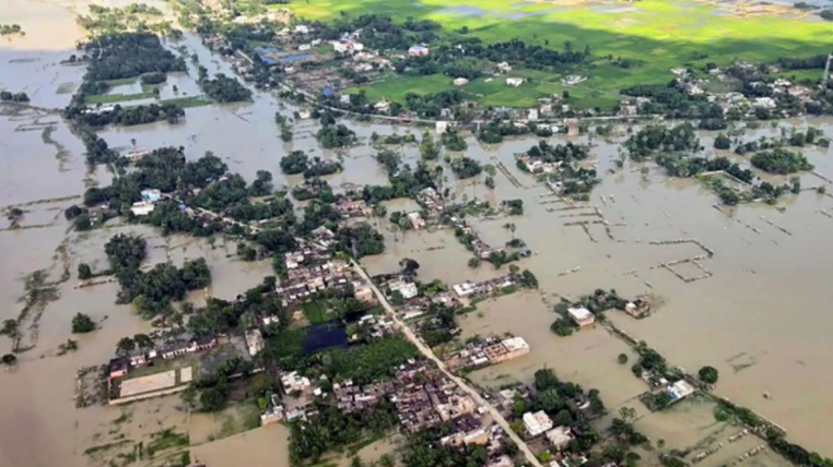
East Champaran floods latest news: The flood situation in East Champaran, Bihar, has worsened after the Gandak River crossed the danger level and breached a ring bund near Sareya Pandet Tola in Areraj block. Floodwater spread toward several nearby villages, affecting homes, agricultural land and local transport. Authorities have intensified monitoring, rescue preparations and relief measures in the affected areas.
The latest developments are linked to exceptionally high water levels in the Gandak basin following heavy rainfall in Nepal and northern Bihar. Several districts, including East Champaran, West Champaran, Gopalganj, Saran, Muzaffarpur and Vaishali, are facing flood-related risks.
East Champaran Floods Today: Top Headlines
- Gandak River rises above the danger level in East Champaran.
- Ring bund breach reported near Sareya Pandet Tola in Areraj.
- Floodwater has entered low-lying villages.
- More than 100 houses were reported affected in the initial breach area.
- Paddy fields have been submerged.
- Schools and anganwadi centres have been closed in affected locations.
- Boats are being used for movement in flooded areas.
- NDRF teams and local divers have been deployed.
- Authorities are preparing evacuation and relief arrangements.
- Bihar officials are monitoring the Gandak and vulnerable embankments.
Gandak River Flood Situation in East Champaran
The Gandak River has been at the centre of the latest East Champaran flood news. A ring bund near Sareya Pandet Tola was breached late Monday night, allowing water to spread rapidly into nearby low-lying areas.
Reports from the affected Areraj block said water reached depths of approximately 3 to 5 feet in some locations. Nawada, Mashrauliya and Sareya panchayats were among the areas affected by the rising water. More than 100 houses were reported to have been inundated, while residents moved to safer locations or rooftops.

Agricultural fields have also been affected, with paddy crops submerged by floodwater. The flooding has created additional difficulties for farmers ahead of the harvesting period.
Nepal Rainfall and Gandak Water Surge
The current flooding is part of a wider hydrological situation across the Gandak basin. Heavy rainfall in Nepal’s catchment areas produced a major increase in river discharge downstream.
The Water Resources Department reported that 543,500 cusecs of water was recorded at the Valmikinagar Gandak Barrage. The Gandak subsequently reached a record water level of 91.25 metres at the Bagaha gauge, exceeding the previous highest flood level of 90.90 metres recorded in 2024.
The unusually high discharge placed pressure on embankments at several locations and contributed to flooding concerns across northern Bihar.
Bihar Government Monitors Flood Situation
Bihar Chief Minister Samrat Choudhary conducted an aerial survey of flood-affected districts, including East Champaran, Gopalganj, Vaishali and Saran.
The Chief Minister reviewed river levels, barrage discharge and embankment conditions and directed officials to maintain close monitoring of vulnerable and low-lying areas. Officials were also instructed to coordinate with SDRF and NDRF teams and remain prepared for rescue operations.
Relief camps and community kitchens have been arranged in some flood-affected locations to provide food and assistance to residents.
Villages Face Waterlogging and Evacuation Concerns
The flooding has disrupted normal life in several villages. Residents in affected areas have reported difficulties obtaining drinking water and fodder for livestock. Boats are being used where roads have become inaccessible.
Local administration teams are working to plug the breached section and prepare evacuation arrangements. Dry rations and polythene sheets are also being arranged for affected families.
Residents living close to rivers and embankments have been advised to follow instructions from local authorities and move to safer locations if evacuation orders are issued.
East Champaran Weather Update
Weather conditions remain an important factor in the flood situation. Continuous rainfall across parts of Bihar and Nepal has contributed to rising water levels in rivers including the Gandak, Kosi and Bagmati.
The India Meteorological Department has issued warnings for heavy rainfall in East Champaran, West Champaran and Gopalganj, with rain and strong winds expected in parts of Bihar.
Further rainfall could affect river levels and complicate rescue and relief operations, making official weather and district-level advisories important for residents.
East Champaran Flood Relief and Helpline
The East Champaran district administration has published a dedicated Flood Disaster helpline: 06252-242418. Residents needing emergency flood-related assistance can contact the district administration through the listed number.
People in flood-prone areas should avoid entering fast-moving water and should follow evacuation and safety instructions issued by local authorities.
What to Watch Next
The immediate focus remains on monitoring the Gandak River, repairing vulnerable embankments, evacuating residents where necessary and maintaining supplies of food, drinking water and medicines.
Officials are also watching downstream water levels because the effects of a major upstream discharge can continue moving through the river system after the initial peak has passed.
Latest East Champaran Flood Update
The latest East Champaran floods have been driven by rising Gandak River levels and an embankment breach in the Areraj area. Floodwater has affected villages, houses and farmland, while government agencies and disaster-response teams are working on rescue, evacuation and relief preparations.
The situation remains dynamic, and residents should rely on official district administration, weather and disaster-management updates for information about evacuation, road conditions and relief services.
