
Table of Contents
Top Headlines
- No active cyclone warning is currently in force for Odisha, according to the latest reports citing the India Meteorological Department (IMD).
- A low-pressure area may develop over the Bay of Bengal around September 19, but officials have cautioned against circulating unverified cyclone claims.
- IMD has forecast heavy rainfall across several parts of India on September 16, including the Andaman and Nicobar Islands, Assam, Meghalaya, Punjab, Haryana, Chandigarh and Delhi.
- Sub-Himalayan West Bengal, Sikkim, Tamil Nadu, Puducherry and Kerala are also expected to experience significant rainfall activity.
- Thunderstorms and lightning are forecast in Bihar, Jharkhand, Odisha, Rajasthan and Jammu & Kashmir-Ladakh during the next few days.
- Weather conditions over the Bay of Bengal remain active, with widespread rain and thunderstorms reported in the latest marine forecast.
- Fishermen and coastal communities are advised to follow official IMD warnings before entering the sea.
- Authorities are monitoring developing weather systems as India’s southwest monsoon season approaches its later phase.
Cyclone News Today: What Is the Latest Situation?
The latest cyclone news in India is closely linked to developing weather systems over the Bay of Bengal. However, current reports do not indicate that a named cyclone is threatening India’s east coast today.
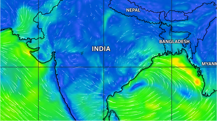
The IMD’s latest cyclone bulletin archive shows that recent weather monitoring has focused mainly on low-pressure systems and heavy rainfall rather than an active landfalling cyclone. The department’s September 16 updates include warnings for very heavy rainfall over parts of northeastern India.
Reports from Odisha also say that there is currently no cyclone warning, while a low-pressure system could develop around September 19. Weather officials have urged people to rely on official forecasts rather than social-media messages claiming that a cyclone has already formed.
Bay of Bengal Weather Update
The Bay of Bengal remains an important area to watch because low-pressure systems developing there can influence rainfall and wind conditions across eastern and southern India.

The latest World Meteorological Organization marine bulletin, issued using India Meteorological Department data, forecasts fairly widespread rain and thunderstorms over parts of the Bay of Bengal between September 16 and 17. Wave heights are generally forecast around 1 to 3 metres, with some areas experiencing poor visibility during rain and thunderstorms.
These conditions are important for fishing communities, shipping and coastal transport.
Heavy Rainfall Forecast Across India
The weather situation today extends beyond the possibility of a future cyclone. The IMD has forecast heavy rainfall over several states and Union Territories.
According to the latest national weather update, Andaman and Nicobar Islands, Arunachal Pradesh, Assam, Meghalaya, Haryana, Chandigarh and Delhi are among areas expecting heavy rainfall on September 16. Kerala, Mahe, Punjab, Sub-Himalayan West Bengal, Sikkim, Tamil Nadu, Puducherry and Karaikal are also expected to experience rain.
Thunderstorms and lightning may affect Bihar, Jammu and Kashmir, Ladakh, Jharkhand, Odisha and Rajasthan over the next two to three days. Similar unstable weather is possible in Andhra Pradesh, Chhattisgarh, Gujarat, Madhya Pradesh, Uttar Pradesh and Uttarakhand.
Odisha and West Bengal Weather
Eastern India remains particularly important because of its proximity to the Bay of Bengal.
A recent low-pressure system over the northern Bay of Bengal previously brought heavy rain to West Bengal, including Kolkata and several surrounding districts. The system subsequently moved toward the northwest Bay of Bengal.
The current situation is being monitored for any further development. Residents in coastal Odisha and West Bengal should follow updates from the IMD and local disaster-management authorities rather than relying on unofficial cyclone-tracking posts.
What Happens If a Low-Pressure Area Develops?
A low-pressure area does not automatically become a cyclone. Such systems can weaken, remain as low pressure or intensify depending on atmospheric and oceanic conditions.
Meteorologists examine sea-surface temperatures, atmospheric circulation, wind shear, moisture and the system’s movement before determining whether it is likely to strengthen into a depression or tropical cyclone.
Therefore, the possible development of a low-pressure area around September 19 should not be interpreted as a confirmed cyclone threat. Current official warnings should be checked regularly as forecasts can change.
Safety Measures for Coastal Areas
People living near India’s eastern coastline should keep monitoring official weather bulletins if a low-pressure system develops.
Fishermen should avoid entering rough seas when authorities issue restrictions. Residents in low-lying areas should also remain alert to waterlogging and flooding during periods of intense rainfall.
During thunderstorms, people should avoid open areas, isolated trees and exposed rooftops. Local authorities may issue additional instructions if rainfall or wind conditions deteriorate.
Cyclone Tracking and Official Updates
The IMD remains India’s primary source for official cyclone and severe-weather warnings. Its bulletins provide information about developing depressions, cyclonic circulations, rainfall forecasts, wind speeds, sea conditions and possible impacts.
